
 Hvide Sande
Aarsdale
Taulov
Midtjyllands Airport
Dalby
Stige
Terndrup
Hjallerup
Hurup
Hvide Sande
Aarsdale
Taulov
Midtjyllands Airport
Dalby
Stige
Terndrup
Hjallerup
Hurup
Stribfyr (Strib Fyr) on the map, Middelfart, Denmark
Photo
Where is located Stribfyr (Strib Fyr)
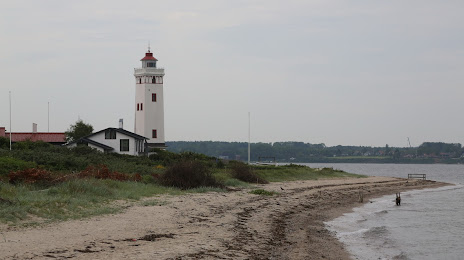
Stribfyr (Strib Fyr) — local attraction, which is located at Tjærepletten 22, 5500 Middelfart, Denmark and belongs to the category — lighthouse. Average visitor rating for this place — 4.3 (according to 123 ratings, information from open sources and relevant for 2022).
Exact location — Stribfyr (Strib Fyr), marked on the map with a red marker.
You can get directions to Stribfyr (Strib Fyr) on the map from your location.
What else is interesting in Middelfart? You can see all the sights if you go to the city page.
Coordinates
Stribfyr (Strib Fyr), Denmark coordinates in decimal format: latitude — 55.54275106424498, longitude — 9.756926825471789. When converted to degrees, minutes, seconds Stribfyr (Strib Fyr) has the following coordinates: 55°32′33.9 north latitude and 9°45′24.94 east longitude.
Nearby cities
The largest cities that are located nearby:
- Odense — 42 km
- Aarhus — 79 km
- Kiel
 (Germany) — 132 km
 - Aalborg — 172 km
- Malmö
 (Sweden) — 204 km
 - Rostock (Germany) — 218 km
- Bremerhaven (Germany) — 230 km
- Bremen (Germany) — 275 km
- Groningen
 (Netherlands) — 328 km
 - Hanover (Germany) — 345 km
- Wolfsburg (Germany) — 347 km
- Emmen (Netherlands) — 355 km
- Brunswick (Germany) — 361 km
- Hildesheim (Germany) — 370 km
- Salzgitter (Germany) — 372 km
- Osnabrück (Germany) — 374 km
- Szczecin
 (Poland) — 391 km
 - Bielefeld (Germany) — 392 km
- Magdeburg (Germany) — 395 km
Distance to the capital
Distance to the capital (Copenhagen) is about — 177 km.