 Warner Robins
  Wantagh
  Bethel
  Misty Hill Farm
  United States
  Wakonda Beach (R33) Airport
  Wilmington
  Poland
  Miami International Airport
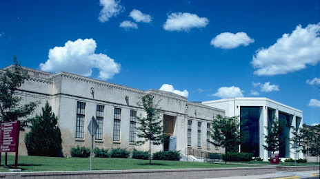
Panhandle-Plains Historical Museum on the map, Amarillo, United States
Photo

Where is located Panhandle-Plains Historical Museum
Panhandle-Plains Historical Museum — local attraction, which is located at 2401 4th Ave, Canyon, TX 79015, United States and belongs to the category — museum. Average visitor rating for this place — 4.8 (according to 423 ratings, information from open sources and relevant for 2022).
Exact location — Panhandle-Plains Historical Museum, marked on the map with a red marker.
You can get directions to Panhandle-Plains Historical Museum on the map from your location.
What else is interesting in Amarillo? You can see all the sights if you go to the city page.
Coordinates
Panhandle-Plains Historical Museum, United States coordinates in decimal format: latitude — 35.08540883164377, longitude — -101.87899664082971. When converted to degrees, minutes, seconds Panhandle-Plains Historical Museum has the following coordinates: 35°5′7.47 north latitude and -101°52′44.39 east longitude.
Nearby cities
The largest cities that are located nearby:
- Lubbock — 182 km
- Wichita Falls — 339 km
- Abilene — 364 km
- Oklahoma City — 389 km
- Norman — 397 km
- Pueblo — 413 km
- Albuquerque — 432 km
- Valencia — 445 km
- Colorado Springs — 475 km
- Wichita — 479 km
- Denton — 488 km
- Fort Worth — 499 km
- Frisco — 517 km
- Arlington — 518 km
- Carrollton — 521 km
- Irving — 526 km
- Grand Prairie — 526 km
- Tulsa — 531 km
- Plano — 534 km
Distance to the capital
Distance to the capital (Washington) is about — 2240 km.
