 Warner Robins
  Wantagh
  Bethel
  Misty Hill Farm
  United States
  Wakonda Beach (R33) Airport
  Wilmington
  Poland
  Miami International Airport
Petaluma Historical Library & Museum on the map, Petaluma, United States
Photo

Where is located Petaluma Historical Library & Museum
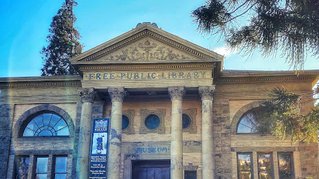
Petaluma Historical Library & Museum — local attraction, which is located at 20 4th St, Petaluma, CA 94952, United States and belongs to the category — museum. Average visitor rating for this place — 4.7 (according to 65 ratings, information from open sources and relevant for 2022).
Exact location — Petaluma Historical Library & Museum, marked on the map with a red marker.
You can get directions to Petaluma Historical Library & Museum on the map from your location.
What else is interesting in Petaluma? You can see all the sights if you go to the city page.
Coordinates
Petaluma Historical Library & Museum, United States coordinates in decimal format: latitude — 38.23254395566999, longitude — -122.64007947511962. When converted to degrees, minutes, seconds Petaluma Historical Library & Museum has the following coordinates: 38°13′57.16 north latitude and -122°38′24.29 east longitude.
Nearby cities
The largest cities that are located nearby:
- Santa Rosa — 24 km
- Vallejo — 36 km
- Richmond — 43 km
- Berkeley — 51 km
- Fairfield — 52 km
- San Francisco — 54 km
- Oakland — 57 km
- Concord — 60 km
- Hayward — 79 km
- Fremont — 95 km
- Sacramento — 106 km
- Sunnyvale — 109 km
- Santa Clara — 114 km
- San Jose — 119 km
- Stockton — 121 km
- Roseville — 130 km
- Modesto — 158 km
- Salinas — 193 km
- Reno — 280 km
Distance to the capital
Distance to the capital (Washington) is about — 3924 km.
